Details of each website feature (for newcomers) Direct links to each website feature (for regulars) Advance news of new developments on my website Summary of all the latest updates Gateway to Welsh Family History Archive Help for those having problems accessing my website A link to the main 'gateway' page to my entire website
To WFHA Homepage

How to Use Grid References

Some of the most useful maps for understanding your family history are those produced by the Ordnance Survey.
Ordnance Survey maps (often known as "OS maps") show fascinating detail, enabling you to identify the individual farms and other properties where your ancestors once lived and worked.
A common way of specifying the location of such features is to quote the Grid Reference. These pages explain how the grid reference system works, and how to quote and interpret grid references.

Maps of Wales Menu page


UK Grid Map
National Grid Reference System

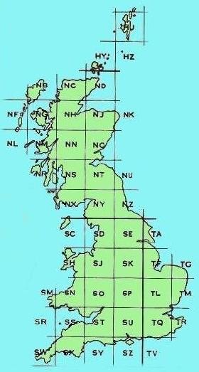
All maps and plans published by the Ordnance Survey carry a system of grid lines, dividing the maps into squares. The grid lines are numbered and provide a single reference system for the whole of Great Britain.
The main grid divides Britain into a number of large squares, 100 kilometres by 100 kilometres in size (see right). Each 100-km square is identified by two letters; e.g. NT, SJ, TL, etc.

Wales is covered by the eight squares shown below:
SH, SJ, SM, SN, SO, SR, SS, and ST

Wales Grid Map

West Wales Map

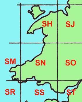
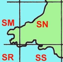
For the purposes of the rest of this explanation, we'll concentrate on the 100-kilometre square "SN" (right) which includes parts of the counties of Cardiganshire, Carmarthenshire, and Pembrokeshire in west Wales.


10-km Grid Map

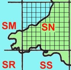
Each of the 100-kilometre squares is subdivided by vertical and horizontal grid lines into one hundred 10-kilometre squares. The diagram (right) shows square SN subdivided into 10-km squares.


Numbered 10-km Grid

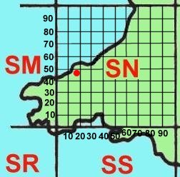
The grid lines forming the 10-km squares are numbered in kilometres.
The horizontal line forming the bottom edge of the 100-km square is labelled zero, and each successive horizontal grid line is labelled at 10-kilometre intervals.
Similarly, the vertical line forming the left hand edge of the 100-km square is labelled zero, and each successive vertical line is labelled at 10-kilometre intervals.

Each 10-km square can be identified by quoting:

  • its distance east of the left hand edge of the 100-km square, known as its easting; and
  • its distance north of the base of the 100-km square, known as its northing
The square containing the red dot is therefore square "10 40", where the easting (always quoted first) is 10, and the northing is 40.
The full grid reference for the square is "SN1040". Adding the prefix "SN" to the grid reference tells us in which 100-km square the smaller square is situated.


Landranger sheet 145 coverage
Grid References on Ordnance Survey Maps

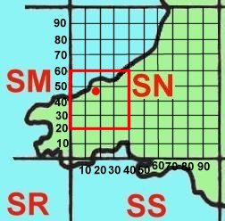
Wales is covered by 19 maps in the OS Landranger series.
The red square in the diagram (right) shows the area covered by just one of those maps: Landranger sheet 145. You can see that it covers an area of 40 km by 40 km.
In the top left (northwest) corner of the OS map is square SN0050. This square is actually situated in the ocean - part of Cardigan Bay.
At the bottom right (southeast) corner of the OS map is square SN3020.


Landranger detail

This is a scan of the top left corner of OS Landranger sheet 145. The corner is marked "SN" to remind us that we are in the 100-km square labelled SN.

On Landranger maps, each 10-km square is further subdivided into one hundred 1 kilometre squares. The squares we can see on the map (right) are formed from blue grid lines, spaced 1 kilometre apart.
Along the edges of the map are marked the eastings (along the top) and northings (down the side) of these grid lines.
The left hand edge of this map has an easting of 00 (zero), and its top edge has a northing of 60. You can confirm that this is correct by referring to the previous diagram.
The top left 1 kilometre square has an easting of 00, and a northing of 59. Its grid reference is therefore SN0059.

Note the misprint on this OS sheet. The third vertical grid line is erroneously labelled "30", when it should be "03"!!


Landranger detail

This is a scan of the bottom right corner of OS Landranger sheet 145. The corner is marked "SN" to remind us that we are still in the 100-km square labelled SN (some sheets in the Landranger series cover areas from two or more different 100-km squares).

Again, the squares we can see on the map (right) are formed from blue grid lines, spaced 1 kilometre apart.
Along the edges of the map are marked the eastings (along the bottom) and northings (down the side) of these grid lines.
The right hand edge of the map has an easting of 40, and the bottom edge has a northing of 20. Check again that this is correct by referring to the last but one diagram.
The bottom right 1-kilometre square has an easting of 39, and a northing of 20. Its grid reference is therefore SN3920.


The picture below is a scan of another part of the same OS Landranger sheet 145, this time including the area surrounding the town of Cardigan (Aberteifi). I've marked in black the eastings and northings of the vertical and horizontal grid lines. Normally, with the map in front of you, you could check these from the markings on the edges of the sheet, as in the two previous scans. Notice that on the right, the northings are repeated in blue on the map itself to aid identification.

Annotated Landranger detail

Most of the town of Cardigan is contained within the two 1-km squares whose grid references are SN1746 and SN1846. We could therefore quote either of these grid references to locate the town of Cardigan.
Using the letter combination (e.g. SN) plus four digits (e.g. 1746) enables us to locate or describe the location of a feature with an accuracy of 1 kilometre - but we can go one step further. In our imagination we can subdivide each 1-km square into one hundred smaller squares, each only 100 metres across. We can then define the location of a feature to within 100 metres.
For example, consider the feature enclosed in the small red circle. The name alongside indicates it is a property, probably a farm, called Pen-Lan. This feature is in the 1-km square whose grid reference is SN1946. However, its easting is actually between 19 and 20 - we might guess its easting is about 19.3 km. Similarly, its northing is actually between 46 and 47 - let's say about 46.7 km. We can therefore refine the grid reference and use six digits rather than four to improve accuracy. We now quote the grid reference of Pen-Lan farm buildings as SN 193 467, or SN193467.
With larger scale maps, it's possible to use 8-figure grid references, giving an accuracy of 10 metres.

Now find out more about Ordnance Survey maps.


Maps of Wales Menu page

Welsh Family History Archive

Details of each website feature (for newcomers) Direct links to each website feature (for regulars) Advance news of new developments on my website Summary of all the latest updates Gateway to Welsh Family History Archive Help for those having problems accessing my website A link to the main 'gateway' page to my entire website