
Selecting the Best Maps
If all you want to see are small towns (and large villages), you can to consult road atlases, but once you know the area where your ancestors lived, you need to study a more detailed map or street plan. The notes below will help you make the right choice.
Click on the daffodil to return to my Welsh Family History Archive.
Maps of Wales Menu page
 1. Travel Route Maps and Road Atlases
These maps are useful for navigating your way around Wales by road and getting you to the general area where your ancestors lived. They are available in book form, each double-page spread covering an area of perhaps 50 miles by 70 miles or more. The maps are to a scale of 3 or 4 miles to the inch, and show major roads and surfaced minor roads. The smaller lanes and villages are not shown. The main route maps on websites such as Bing, Streetmaps, and Google Maps show a similar level of detail, although it is possible to use the zoom facility to obtain more detail.
2. Medium and Large Scale Maps
The Ordnance Survey (OS) produces a range of maps covering the whole of Wales. Maps from the OS range described below are all available in the form of folded sheets:
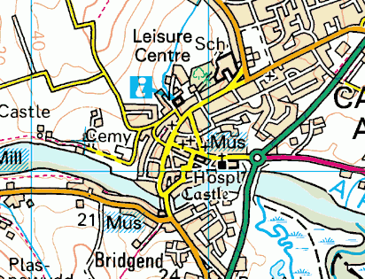
Landranger Series - (Scale 1:50,000 or 1¼ inches to 1 mile) These maps cover an area roughly 25 miles by 25 miles. Details include land contours, streams, bridges, tiny villages, churches and chapels, public footpaths and rights of way, and most farms and other large buildings. The example (right) shows the detail found on the Landranger series. This image is centred on almost exactly the same spot as the picture (above right) taken from a Road Atlas.
Once you know the approximate area where your ancestors lived, you simply must get the Landranger map of the area. In some cases you may need more than one map, because your location may be close to the edge of the sheet. You would need about twenty separate sheets from this series to cover the whole of Wales, but you can obtain all these maps on a DVD. (See here for list of sheets)
Relevant sections of Landranger maps can be accessed on the Streetmaps website, centred on the location you have selected by inputting its place-name, postcode, or grid reference.
The first editions of the Ordnance Survey maps were produced in Victorian times, based on surveys undertaken in the 1830s and 1840s. See below for further details of the Victorian OS maps.
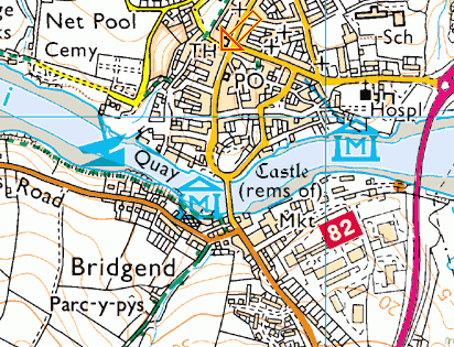
Explorer Series - (Scale 1:25,000 or 2½ inches to 1 mile) These maps are produced on large sheets but cover a smaller area than Landranger maps. All the details of the Landranger series are shown, plus extra details such as most houses and cottages, the names of small farms, and individual field boundaries. They also include features of particular interest to tourists. The example (right) shows the greater level of detail of the town of Cardigan on an Explorer sheet, compared with the earlier example from a Landranger.
Outdoor Leisure Series - (Scale 1:25,000 or 2½ inches to 1 mile) This series is similar to the Explorer series, but is produced to provide convenient coverage of the National Parks, those in Wales being:
- Brecon Beacons (sheets 12, 13)
- Pembrokeshire Coast (sheets 35, 36)
- Snowdonia (sheets 17, 18, 23), and
- Wye Valley & Forest of Dean (sheet 14).
|
Pathfinder Series - (Scale 1:25,000 or 2½ inches to 1 mile) These maps, which covered an area about 10 miles by 15 miles, are no longer being published, having been replaced by the Explorer and Outdoor Leisure series (see above). However, they are still available secondhand and are cheaper than their more modern equivalents.
Relevant sections of modern Explorer and Outdoor Leisure maps may be accessed on the Streetmaps website, centred on the location you have selected by inputting its place-name, postcode, or grid reference.
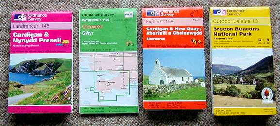
Below: Examples of the range of OS maps described above.
Left to right: Landranger; Pathfinder; Explorer; Outdoor Leisure.
Further details on the Ordnance Survey Website.
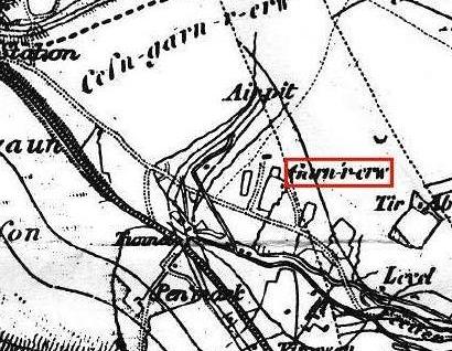
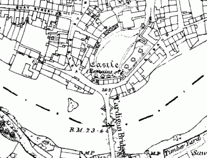
Victorian First Edition Series - (Scale 1:63,360 or 1 inch to 1 mile) These maps cover an area about 20 miles by 30 miles. The maps are monochrome facsimile reprints of original maps which were published by the OS in the late 19th century. The maps are based on surveys undertaken in the 1830s and 1840s, but have later details (e.g. railway lines) added. They give a fascinating glimpse of the Welsh landscape as it was in the mid 19th century. Some of the names are difficult to read (see example right), so good lighting and a magnifying glass are essential. Eighteen sheets are required to cover the whole of Wales. (See here for list of sheets)

Large Scale Old Maps Series - (Scale 1:10,560 or 6 inches to 1 mile) These highly-detailed maps are monochrome facsimile reprints of original 6 inch to 1 mile maps which were published by the OS in the late 19th century. The maps are based on surveys undertaken earlier in the century, but have later details added. They identify features such as field boundaries, the names of public houses, churches, chapels, smithies, mills, and more (see example, right). Scans of these maps can be accessed on line at the Old Maps website from where facsimile reprints can also be purchased. Each map covers an area of about 5 miles by 4 miles. The quality of reproduction varies with locality: generally, rural areas are reproduced more clearly than urban areas.
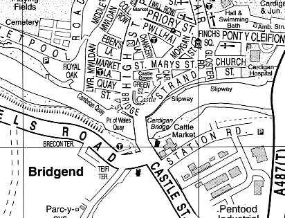
 3. Town Plans
If your ancestors were town dwellers, you'll be fascinated by the superb large scale town plans produced by the Ordnance Survey from the second half of the 19th century onwards (see example, right).
The original Ordnance Survey town plans were drawn to a scale of 1:2,500 (25 inches to 1 mile).
High resolution scans of many of these town plans, as well as maps of rural areas to the same scale, may be accessed on-line at the Old Maps website from where facsimile reprints may be purchased.
Also, many of the town plans have been republished by Alan Godfrey of Gateshead in a series known as The Godfrey Edition but the Godfrey Edition reprints are reduced in scale to 1:4,340 (about 15 inches to 1 mile). The back of each sheet contains historical information and in many cases facsimile reprints of relevant extracts from a contemporary trades directory such as Kelly's. Because of the large scale, each sheet only covers a small area, about 1 × 1½ miles. There is no street index included. Over 1,500 Godfrey Edition sheets have been published, with an increasing number of Welsh towns represented, mapped between 1900 and 1915. Check here to see whether your Welsh town is available in the Godfrey Edition series.
Godfrey Edition maps may be obtained from Alan Godfrey's own On-line Mapshop or other specialist map suppliers (see here for details).
 4. Street Atlases
Again, if your ancestors were town dwellers, you may find a modern street atlas and gazetteer or street index helpful in locating their address.
Many of the streets, rows, and terraces mentioned in the 19th century censuses still exist – and in lots of cases the original houses have survived. A street plan will be useful in identifying their location.
Typically, street atlases are drawn to a scale of 4 inches to 1 mile (see example, right).
Various UK publishers offer street atlases of Welsh towns and cities, either in book form or as folded sheets; e.g. Geographers' A-Z series, Ordnance Survey, and the Streetezee (formery Streetwise) Street Atlases.
Street plans of urban areas can be accessed on-line at websites such as Streetmaps and Google Maps (which also provides high-resolution satellite imagery - see section 6, below).
 5. Tithe Maps
Tithes were payments made to the local parish by all landowners. Tithe maps were first drawn up in the 18th century to try to settle disputes over the payment of tithes by the owners of land or property.
The purpose of tithe maps was to provide a definitive record of the size, location and ownership of every parcel of land and property. Most tithe maps were completed between the 1830s and 1850s. Each map covers only a small area, but to a large enough scale for all the necessary details to be included.
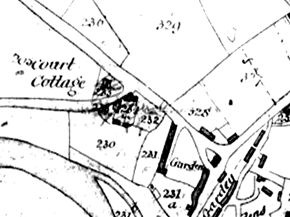
Each building, field or plot of land is drawn in, its boundaries shown and an identification number allocated (see example, right).
Tithe maps were used in conjunction with an apportionment or schedule giving a list of names (corresponding to the ID numbers on the map), identifying the owner of each piece of land or building. The apportionment also gives the area of each piece of land, and its description or name (if it has one). Tithe apportionments were recorded as separate documents, to be used in conjunction with the relevant map.
For example, a parcel of land near the centre of the map has the number 230 written on it. Reference to the apportionments gives a description of the land (or property) corresponding to number 230, plus the names of the occupier and the landowner.
Tithe maps are normally available for study in the County Archives, Public Libraries, and the National Library of Wales, Aberystwyth. For further details, see Tithe Maps of Wales on the National Library of Wales website.
 6. Satellite Images
Satellite images provide a fascinating way of studying rural and urban Welsh landscapes from space. Details of buildings, roads and tracks, fields, rivers and railway lines can all be identified. The satellite images are in full colour, and show the contemporary landscape with a resolution high enough to identify motor vehicles and road traffic markings.
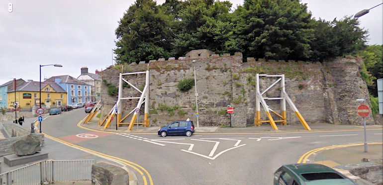
Satellite images can be accessed on-line at websites such as Google Maps, which also provides an optional road-map overlay to help in identification. A further development on Google Maps is the 'StreetView' facility which provides photographic coverage of most of Wales (and the rest of the UK) from street level. The StreetView example (below) shows the junction between Bridge Street and Strand from the bridge over the River Teifi at Cardigan, which is also illustrated on Google's satellite image (above right).
|